Terrains vary tremendously depending on the location you visit; some areas are known for their sandy dunes, others for their pristine white sand bars a mile long, while others are known for their magnificent mountains and volcanoes. Humans have marveled at these wondrous natural occurrences and formations since the beginning of time.
Visiting Japan, and Love Natural Geological Formations? Travel to Mt. Aso
One of these earthly marvels can be found in the town of tiny town Aso in Japan is the Aso Kuju National Park. Nestled in this park is Japan’s largest volcano named “Mt. Aso”, or “Aso-san” (阿蘇山) in Japanese. It has quickly become a famous tourist destination, despite being due to erupt at any given moment, according to Scientists. It goes up and down on several volcanic alert levels, depending on the behavior of the volcano.
An Open Mountain Filled with Molten Magma
Belonging to the Kumamoto Prefecture in Kyushu island, Mt. Aso stands tall at 1,592 meters high from sea level. It is a caldera volcano, which means the volcano’s terrain sinks in (compared to other volcanoes that stick out) resembling a cauldron. It is now considered a UNESCO World Geo Park and has been since September of 2014.
The History of Mt. Aso
Mt. Aso became a caldera volcano because of a series of volcanic eruptions; large amounts of magma flowing out of its chambers around 90,000 to 300,000 years ago. The volcanic structure was not able to sustain the amount spewing off its chambers as it was emptying itself, so it caved in. Often, this is due to the volcano’s weak ducts that are unable to support the weight of the magma that spewing out that causes the collapse. The magma that was released melds into form with the newly-created a fracture on the land, which would lead to its pot-like formation.
Over the course of those thousands of years, four eruptions of a giant magnitude occurred. The biggest of these four that did the most damage was the fourth eruption. This volcanic expulsion of Mt. Aso that had erupted 90,800 years ago reached 600 square kilometers in area. The amount of ejecta was so much, its ashes reached half of the entire island of Kyushu, and could have formed (in terms of volume) an entire Mt. Fuji on its own.
That fourth eruption also created the cones of Mt. Naka, Mt. Taka, Mt. Kishima, and Mt. Eboshi. This leaves Mt. Neko as the oldest cone of them all and was formed before the fourth eruption. Later on, the deposits of the pyroclastic flow from the Mt. Aso were used to build bridges around Kumamoto Prefecture. So far, there are 320 arched bridges that were made out welded tuff, some of these being cultural monuments, such as the Midorikawa river’s Reitai-kyo and Tsujun-kyo.
How Mt. Aso Stopped an Earthquake
It is known that earthquakes can cause volcanoes to erupt, even if they’re far away from the volcano itself – but apparently, it was recently discovered that the action of moving magma can halt the effects of an earthquake. This was found to be the case when an earthquake struck off the coast of Mt. Aso. News said a team of scientists raced to see the effects this would have on Mt. Aso and found that the ruptures that were caused only reached 6 kilometers deep.
They later found out that the volcano’s inner workings of partially molted magma took the brunt of the force, acting as a cushion to the blow of the movements. Finding out how the fluidity of underground substances works to prevent earthquakes this way from being felt more obviously helps scientists in this field of research to make more comprehensive assumptions in further research and studies.
The Technicalities of Mt. Aso
The coordinates of this volcano are 32°53′04″N 131°06′14″E. It is officially typed as being a “Caldera complex”, and competes with other volcanoes around the world as being one of the biggest. Its caldera measures 25 kilometers long from its northernmost tip to southernmost tip. As for east to west, it measures 18 kilometers. 120 kilometers is how large its circumference. It last erupted in October of 2016.
Mt. Aso is made up of several peaks – five of them to be exact. They all have their own names. There’s Mt. Naka, which is short for its longer name, Nakadake, Mt. Taka, Mt. Kishima, Mt. Eboshi, and Mt. Neko. Mt. Taka owns the peak that hit the 1,592-meter mark, which qualifies Mt. Aso as a tall caldera complex. There is one crater that often smokes, and could start erupting at any time is found on Mt. Naka.
There’s another crater, which is also considered the “first” one; located in the northernmost part of Mt. Aso. That crater has erupted 10 times since 1974, with its most recent one occurring just last year. Within the present-day caldera that was formed due to the explosions long ago is Aso city. There are also other towns located here, namely South Aso-mura and Aso Takamori-cho.

A Guide to The Biggest Active Volcano in Japan; Mt. Aso
Mt. Aso is filled with many different names of areas that hold views, craters, lakes, and plains that are breathtaking. Among these areas, there are the more popular places that are visited, and Mt. Nakadake is one of them. Among the peaks, Mt. Nakadake is where visitors take to when they want to get a good view of the smoking crater and its volcanic wonder.
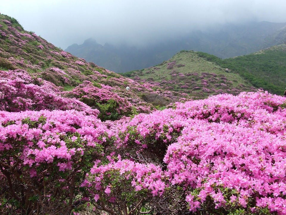
Also in the Mt. Aso area and in close proximity to Mt. Nakadake is plain that has a few barnyard animals, such as cows and horses. This plain is called Kusasenrigahama, and is open to horseback riding during the start of spring, (April) until early winter (mid-December). The views here are spectacular on sunny days, and late Spring to early Summer brings a special flower called “Miyama Kirishima” (an Azalea variant) to bloom.

If you visit in between the seasons of summer and fall, you may see an almost perfectly-shaped cone that holds a crater, brimming green with growing grass. That is the renowned Komekuza. Next, there is a road called “Laputa”, which was named as such because of a movie called “Laputa: Castle In the Sky”, because of its resemblance to many of the movie’s scenes.
Precautions to Take Before You Visit
If you plan to go crater, it is important to check whether it’s open to tourists for that day or not, due to dangerous volcanic activity. Because it had erupted in the last year, it fluctuates on different alert levels. Last February 7, its alert level was dropped to 1, which means that it is open tourists to see, though they are not allowed as close to the crater as they once were.
Other times, guests are not allowed to go near the area around the crater because of sudden volcanic activity or gases that it spews out, which is unsafe for humans to breathe. Before you head there, it is best to find out if the volcano is calm enough for you to be able to visit it at all. You may do this by checking the website of Aso city. It has a specific page that includes updates on the statuses of the craters.
What is The Weather Like Around Mt. Aso?
Because of the high altitudes, Mount Aso can get very cold during the winters. Mt. Aso's coldest average lows are in January and February, which as -5 and -4.2 degrees Celsius respectively. As for summer in July and August, Mt. Aso’s average high hits only 22.3-23.3 degrees Celsius.
Mt. Aso’s climate sits between two kinds: a humid continental climate, and a humid subtropical climate, mainly because of its high elevation of 1,143 meters. Expect a whole lot of rain if you’re visiting any time during June and July, as it may not let you fully experience visiting the crater zone.
Getting to Mt. Aso while In The Kumamoto Prefecture
There are many ways to get to Mt. Aso, once you are in the Kumamoto Prefecture. One of them is to take the limited express (by bus) called the “Kyushu Odan Express” (九州横断特急). It only makes four round trips each day and takes you directly to Mt. Aso. It takes around 60 minutes and will cost you around 2240 yen. You may find the Kyushu Odan Express in Kumamoto Station, Kumamoto Airport, and the bus Terminal of Kumamoto Kotsu Center.
As for using the train, begin by taking the JR Hohi Line. This usually takes an hour and 20 minutes from around the prefecture, and the ticket will set you back 1,110 yen. You can also take a private car, as parking lots were constructed right by the crater for those who prefer to drive themselves back and forth. A fee of 600 yen will have to be paid for toll going there.
From Outside the Prefecture
If you’re not in the Kumamoto Prefecture, you can take the JR Kagoshima or Kyushu Shinkansen from other Prefectures like Kagoshima and Fukuoka. In Beppu, which is in the Oita Prefecture in Japan, there are also buses and trains that can connect to Mt. Aso, but seeing as it’s further away from the Prefecture, it’s also a lot pricier. Expect to pay 2950 yen for a three-hour bus ride to Mt. Aso from Beppu, and 3740 yen for a 2-hour train ride.

Getting Around Once You’re in Mt. Aso
If you aren’t using a private car to get up to the mountain, you’re going to need to use cable cars. Prepare a 1080 yen each person to pay for a roundtrip, as one way up or down costs 540 yen. Two different cable car lines function for this mountain; one on the west called Aso Nishi, and one on the east, called Aso Higashi.
Aso station usually has buses that take you straight to these cable cars, while Aso Higashi leaves you on foot, so you must take another train to a station which is 2 stops away, and get off a stop called Miyaji station. Once you arrive at Miyaji, you make your way on foot to the east cable car station, which is just up the road.
What to See Around Mt. Aso
Aside from the natural formations that were mentioned earlier (all part of Asosan), there are other sights to see, such as the Aso Volcano Museum, which vividly describes the history of the volcano and explains the science behind it. Then there’s the Aso Shrine, which is specifically dedicated to gods that have control over the abundance of agriculture. There are also many onsens that take advantage of the heat that the volcano emits, so you may want to consider bathing in one of them.
Hotel Suggestions for When You Go to Mt. Aso
Aso Base Backpackers, which is a dormitory-style hotel with private room choices, offers nights at 2800 yen each person. It was given a rating of 9.6, “exceptional” in the case of one of the hotel websites it is highlighted in. It is only 3 minutes away by foot from JR Aso rain Station, this is a backpacker’s haven. Guests love staying here, as it is very minimal and bare-bones, which is just what some people prefer when they go to Mt. Aso.
As for those who want to be pampered a little, or if you’re bringing a child along, there’s Aso no Shiki, which scores a rating of 9.3. A night in this accommodation for one adult will cost you 17,984 yen per individual booking for one person. Then again, it’s a fantastic ryokan which gives you excellent service, access to bedrock baths for private use; both indoors and outdoors. You get to enjoy the entire ryokan experience in one of the most top-rated ryokan in Mt. Aso.
Have A Map Of Mt. Aso to Familiarize Yourself With the Area
Google maps is a great accomplice when it comes to maps, but it’s good to have a copy of the map of Mt. Aso. If you go to the website of Aso, they have maps with descriptions written in English to help, pointing out the different stations, mountains, and areas that you will deal with in your visit to Mt. Aso.
It can be difficult to travel Mt. Aso, but it’s worth the shot. Speaking of shot - don’t forget to bring your camera. If you are lucky with the weather, “scenic” is an understatement for the views you get to take in up in Mt. Aso.