The word “Oshima” leads to an assortment of references, labeling multitudes of both people and places. It is most often used in the context of Japanese locations, as Oshima is repeated and used to name different islands, a district, a subprefecture, villages, towns, a volcano and etcetera. This article will explore the different ways the word Oshima is used.
The Meaning of the Word Oshima
You may be wondering why “Oshima” is used so often. The reason for this is because Oshima means “large island” in Japanese. Even though some islands aren’t exactly large, a few of them can and still do carry the name, Oshima. It also helps that Japan is an archipelago, and contains so many islands that many of them share the Oshima title. You may hear this word being pronounced as “Kojima” or “Ojima”.
At the same time, Oshima is also a Japanese family name. It isn’t very rare, as quite many people have this last name; some of them even living within the United States. So far, the historical document count that contains the name “Oshima” has reached 7051, according to the ancestry website. These documents include birth, marriage, and death certificates, immigration records, census lists, voter lists, military records, and more. It wouldn’t be so rare to meet a person with this last name.
Notable People with “Oshima” as Surnames
Being a bit of a common name, many people have taken this surname and risen to fame – for both great and not-so-great actions. Hiroshi Oshima, for example, was a Japanese Ambassador when world war II struck, serving Nazi Germany. And then there’s Nagisa Oshima, a director of films. Michiru Oshima is a famous composer who makes music for tv, movies, and video games.
The Islands
Spread all throughout Japan are the different Oshima islands, all unique from each other, and encompassing different areas. Although they share a part of their names with each other. They still differ in terms of their geography, island specifications, history, and the culture of those living there.

Nii Oshima, From the Geiyo Islands
Situated around a kilometer and a half northeast of Japan’s Niihama city is the small island of Nii Oshima, which is written as “新居大島”. Nii Oshima is also sometimes simply called Oshima, written as “大島”. This island falls under the authority of the Ehime Prefecture and sits amidst the Seto Inland Sea. Size-wise, Nii Oshima measures around 8 kilometers as its circumference, populated by only around 400 people. Considering that so few inhabit Nii Oshima, the island is slowly experiencing depopulation, mostly because it is small and quite isolated to from Shikoku (mainly Niihama), which is where most of the trades and business happen.
Those who live in these islands live off raising crops; a citrus species called “Mikan” and a special variety of white potato. They also farm shrimp. There is a ferry that takes passengers to and from Oshima to Niihama, and departs every hour, taking a 15-minute trip each way. All the way at the bottom of this island, you can find traces of old Shintoism via two shrines. You’ll also find the remnants of an old castle; Oshima castle.
Oshima, Ehime
Another island that is completely different from Nii Oshima is the island named Oshima; written similarly to the previously mentioned one; “大島”. This island is nestled between Shikoku and Honshu, and, just like Nii Oshima, is also in the Seto Inland Sea, and part of the Ehime prefecture. The city of Imabari takes governmental control of Oshima,
This island is integral to the transportation system of Japan, as it serves as one of the connecting islands of the Shimanami Kaido; 59.4-kilometer long expressway that begins at the Nishiseto Onoichi Interchange in Hiroshima, and ends in the Imabari Interchange in Ehime. The two bridges that connect to these islands are the Kurushima-Kaikyo Bridge and the Hakata-Oshima Bridge.

Izu Oshima; An Island Near Tokyo
Found within the collection of volcanic islands known as Izu Archipelago is Izu Oshima. Because this island is very near Tokyo (which is on Honshu island) – 120 kilometers away, to be exact, it is the booming metropolis’ jurisdiction as well. The sea that Izu Oshima is in is the Philippine Sea. It’s also 22 kilometers away to the eastern part of the Izu Peninsula. You can get there by ferry; both regular and high-speed; through Tokai Kisen at the Takeshiba Ferry Terminal.
The existence of this island goes all the way back to 10,000 to 15,000 years ago, or the late Pleistocene period. It measures 91.06 square kilometers. Its coastline is 52 km long. It’s ranked 145 out of the 196 places to visit in Japan; as it has many natural wonders to behold (Volcanic cliffs, Mountains). Visitors can also take a dip in the island’s renowned hot baths; Miharayama Onsen, for 800 yen, or Motomachi Hama no Yu for 400 yen.
Its highest point is Mount Mihara, known as “Mihara San” (“三原山”), which is a 758-meter-tall active volcano. This volcano is found at the very center of the island. Eruptions that have caused evacuations include those that happened during the years 1965 and 1986, with the latest eruption dating last 1990. Despite its activity, many people still live on this island. As of October 2015, its population is numbered at 8,179 people. You may travel there by plane, as it does have a functioning public airport; named “Oshima Kuko”.
Amami Oshima Island
Within the Ryukyu Islands (which is entirely delegated by the Kagoshima Prefecture, under the Oshima Subprefecture), is the Amami Islands/Amami Archipelago. Within the Amami Islands is the Amami Oshima Island, which is the biggest island in the entire set that falls under the Amami Archipelago that sits in between Okinawa and Kyushu.
The Amami Oshima has many different names, as it is part of Japanese subculture. In the Okinawan language, it is spelled “Uushima” (ウーシマ), and the in the Amami language, it is spelled “Ushima” (ウシマ). The island is situated in the East China Sea (the Pacific Ocean faces its eastern side) and has an area of 712.35 square kilometers. Its coastline measures 461.1 kilometers long, while the highest point of the island (605 meters above sea level) is called Yuwandake, or Mt Yuwanda.
The population of this island was at 73,000 during 2013. In the entire Japanese archipelago, it is the 7th largest – that’s if the Kuril Islands aren’t counted. It’s below Kyushu (210 nautical miles south from its southernmost tip) and 130 nautical miles above Okinawa. This island was formed from a volcanic explosion. The weather there is warmer than most of Japan, as it is situated in the more southern region; so winter in January and February isn’t too cold. It is often hit by typhoons, and the duration of its rainy season takes around 5 months; from May until September.
More About Amami Oshima
This island has been around since the Jomon period. The presence of a civilization at that time was proven because of the discovery of artifacts on the island such as pottery and stone tools. Later, the use of the island by Japanese envoys headed towards China, which was currently experiencing the Tang Dynasty, was also documented. They would use the island as a stopover between travels, and this occurred during the Nara period and Heian period.
Back then, the Ryukyu Kingdom governed these islands, including Amami Oshima. Japan was being battered by constant feuds to win the island’s territory, leading up to the Shimazu clan ruling strong in 1609. This was recognized and included by the Tokugawa shogunate in 1624. At that time, those who lived on the island were made to raise sugar cane under restrictive and unfair conditions to pay off high taxes. Many people starved because of this.
When the Meiji restoration took place, Osumi province took in Amami Oshima island, further incorporating them into a Prefecture, which was Kagoshima. American troops settled in the island after the second world war and left in 1953. It was also near this island where Japanese Coast Guard ships sunk a North Korean trawler who engaged them in a scuffle.
A Thriving Island
The island’ still relies on exporting sugar cane, sweet potatoes, and rice. The blaring sun and fertile land help in propagating the crops. As most islands, many who live here make a living off fishing. The island is also famous for distilling shochu, which is a Japanese alcoholic drink that is made from rice, sweet potatoes, barley, brown sugar, or buckwheat. It doesn’t end there – many people enjoy visiting Amami Oshima, so their tourist industry is bustling. Other products Amami Oshima is known for are their hand-crafted silk.
Wildlife Around the Island
Animals that populate this island have been found to be endangered, as well as endemic. An example of this is the Amami rabbit, which cannot be found anywhere else on earth except on this island, and Tokunoshima. Other animals that roam freely along its Quasi-national park are habu, which is a species of venomous snake. To lessen the presence of these snakes, Mongoose was placed, but this created an imbalance in the ecosystem, as the mongoose would hunt the endangered Amami rabbit.
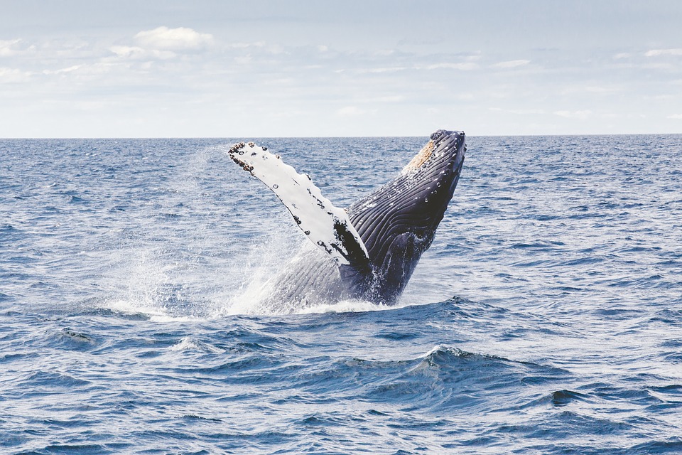
Being near water, marine animals have made numerous appearances – from dugongs to turtles, to dolphins, to whales. Whale-watching has been very popular in this island, as an assortment of whales has been spotted here, like the Humpback Whale, Sperm Whale, Bryde’s whale, False Killer Whale, Spinner Whale Spotted Whale, and most notably the North Pacific right whale; which tops the list of most endangered whale species.
The Language of Amami Oshima
Emerging from this island comes a form of sign language; “Amami Oshima Sign Language”, and two different language dialects; namely the Southern Oshima dialect, and the Northern Oshima dialect. The number of people who speak the northern version far outweighs those who speak the southern dialect; 10,000 to 1,800. With both languages labeled by UNESCO as endangered, the residents of this island of have seen older days are usually the ones who speak them. The rest of the younger population speaks same Japanese as the rest of the country.
Other Places Named Oshima
A handful of old towns and villages were named Oshima, well into the mid-2000’s. During this period, many of them were merged to form larger cities, thus becoming easier to identify. Here are a few examples.
Within the Munakata District of the Prefecture of Fukuoka was the village of Oshima, called “Oshima-mura”. The village comprised of two islands; one called Okinoshima, and the other, Oshima. It was a small village, measuring only 8.14 square kilometers as its area. It had 873 people living there as of 2003. Eventually, this village merged with Munakata city on March 28, 2005.
The Kitamatsuura District, which is in the Prefecture of Nagasaki, had a village called Oshima. Although it was merged into Hirado city during October 2005, it had a bustling population of 1,659 in 2003, with 15.52 square kilometers encompassing its entire area. Being part of a small island compared to Honshu, those who live here often make a living out of farming fish. Agriculture also plays a large part in the income of the island, producing tobacco, potatoes, and rice every day.
Also in Nagasaki, but in a different district – one called “Nishisonogi”, is a town called Oshima. This town was called Oshima-cho by the locals, represented in Japanese as “大島町”. It was quite a large town, holding 6,046 people in 2003, with a total area measuring 13.33 square kilometers. It merged on April 1, 2005, with other towns (Saikai, Osekto, Seihi, and Sakito), forming Saikai City.
Oshima; The Name of a Japanese Gunboat
The Imperial Japanese Navy owned a steam gunboat that was named “Oshima”. This was done with respect to the island of Izu Oshima. It was ordered as early as 1889, built in the Onohama Shipyards. It was laid down on the 29th of August 1889, launched on October 14, 1891, commissioned on March 31, 1892, and struck on June 15, 1905.
This ship was patterned after the Maya class with slight modifications, was partially assisted by Louis-Emile Bertin, a French naval architect, in her design, and was notably the first in all of Japan to have a vertical triple-expansion steam engine. The ship sank in Liaotung Bay, Port Arthur when she accidentally bumped another gunboat named Akagi. This occurred during the Russo-Japanese war. Commander Hirose Katsuhiko was in charge.
There are so many ways that a single name can be used; knowing the intricacies and histories behind how they differ helps in getting to know a country more – and in this case, that country is Japan. Go on a whim; take a bus or ferry, and try spending a beautiful night in one of these islands.